Saturday, March 12, 2011


Fort Sumter was the site of the opening shots of the Civil War. The fort was one of a series of coastal fortifica- tions built after the War of 1812. When South Carolina seceded from the Union, there were four Federal military installations around Charleston Harbor: Fort Mountrie on Sullivan's Island, Castle Pinckney on Shute's Folly Island near the city, Fort Johnson on James Island across from Moultrie, and Fort Sumter at the harbor entrance. The only post garrisoned by more than a nominal number of soldiers was Fort Moultrie under the command of Major Robert Anderson. Anderson concluded that Moultrie was indefensible and, under cover of darkness, moved his troops to Fort Sumter, a mile away.

Sumter, as the only Federal installation of any consequence left, became the focus of the growing dispute between the newly established Confederate states and the Union. The Confederacy demanded that Fort Sumter be surrendered. Union forces refused. On April 11, 1861, Confederate forces began shelling Fort Sumter. For four hours, the Union held its fire, then began firing. However, Sumter cannons did little damage to Confederate positions. At 2 p.m. on the 12th of April, Anderson agreed to a truce. Union troops left the Fort on April 14, having defended the Fort for only 34 hours. The Fort was heavily damaged by Confederate cannon fire.

Picture 1 shows Fort Sumter as it appears today. Note the large black mass arising from the center of the Fort. This massive concrete gun implacement was built after the Civil War. It served as the mounting for several large artillery pieces. Picture 2 shows Fort Sumter as originally built. Note that it was three stories tall with gun implacements at each level. During the Civil War battle, the top two levels were mostly blasted away.

The third picture is a 6.4-inch rifled Parrott cannon, installed in the 1870s modernization of Sumter. Picture 4 shows a mounting for one of the large artillery pieces included in the remodeled Fort Sumter with a view toward open sea. These guns were never used in combat from this Fort.

Fort Pulaski, near Savannah, GA


After the British sacked Washington, DC, during the War of 1812, the
U. S. felt the need for better coastal defenses. Fort Pulaski, named for Count Casimir Pulaski, Polish hero of the American Revolution, is one of a series of forts built along the East Coast of the United States. These forts including Pulaski were traditional masonry (stone) fortifica- tions with fixed cannon placements. They were designed to guard harbors or river estuaries. Construction of Fort Pulaski, begun in 1829, required 25 million bricks and 18 years to complete. By 1860, just before the Civil War, however, its armaments still were not complete and it was not garrisoned.

On January 19, 1861, two weeks after South Carolina seceded from the Union, Georgia seceded also and its governor ordered state militia to seize Fort Pulaski. The successful blockade by Union forces of southern ports and the installation of artillery on nearby islands and shores, put the fort at risk. Pulaski, like other similar forts, was not designed to withstand the capabilities of the newly developed rifled cannon. Its longer range and greater accuracy spelled the end of an era for this type of fixed fortification. Up to this point, cannons had been smooth-bore weapons with limited range and accuracy. The new rifled cannons had approximately twice the range and much greater accuracy.

The Union began shelling Fort Pulaski from its nearby cannon implacements and, in 30 hours, forced the Confederates to surrender. The quick fall of Fort Pulaski surprised and shocked the world as Pulaski was considered a spectacular harbor defense structure. The quick destruction of Pulaski by rifled cannons spelled the end of fixed masonry fortifications and signaled the beginning of mobile defenses such as the Merrimac and the Monitor, the first ironclad warships.

The first picture shows earthen mounds outside the walls of the fort. These underground ammunition bunkers were added after the Civil War. During the shelling of Fort Pulaski, ammunition bunkers within the fort (Picture 4) were exposed to cannon fire when the walls were breeched. The second picture shows a National Park Service employee demonstrating loading and firing a rifled musket of the era. She was able to load and fire only three rounds in probably 90 seconds.

Tuesday, March 8, 2011

Flagler College in St. Augustine, FL


Flagler College, a liberal arts college in St. Augustine, has to have one of the most interesting histories of any small college in the nation. Its main buildings were built by tycoon Henry Flagler, a founding partner of Standard Oil (along with Rockefeller). What is now the college was originally the Ponce de Leon, a luxury hotel built by Flagler because his wife's health required the warm winters of the south.

St. Augustine did not provide the kind of accommodations Flagler was accustomed to so he built the
Ponce in 1883-1884 to accom- modate him and to attract up to 450 of his well-to-do acquain-tances. Being one of the wealthiest men in America, Flagler spared no expense. The building itself is poured concrete. Stained glass windows and chandeliers were designed by Tiffany of New York. Thomas Edison designed and installed the lighting system. The Ponce was the first building to have a totally electric lighting system throughout. Interior woodwork includes carving by some of Europe's finest woodcarners who were brought to St. Augustine to do the work on site. Four carved wooden columns in the entry hall depict women in various stages of pregnancy. From each direction the facial expression as well as her abdomen change.

The Grand Ballroom featured two alcoves above the dance floor where two orchestras provided continuous music. The final seven or eight measures of each orchestra's set was played by BOTH orchestras as a transition to ensure continuous entertainment. The Grand Ballroom is now the student cafeteria, probably one of very few with Tiffany stained glass windows.

Guest rooms prices ranged from $6 to $90 per night. Guests were expected to pay for three months regardless of how long they actually intended to stay. Our student guide indicated that guests paying the higher prices for their lodging, paid the current equivalent of $250,000 for their winter stay. Flagler and his wife frequently dined in the hotel dining room. The seating arrangement ensured that those who paid the higher room rates sat closer to Flagler's table. Those paying $6 a night occupied the far end of the dining hall.

Not all was so posh, however: there were only two bathrooms on each floor of the hotel. The Ponce also had only one safe for all guests' valuables.

Men spent most of the day doing business. Women were expected to spend their day in the salon reading, doing needlework, playing games or music. There were over a dozen crystal chandeliers in the salon to ensure that it was a bright and welcoming setting. Each chandelier was different from the others.

In addition to the Ponce, Flagler underwrote the costs of building several churches in St. Augustine as well as two other hotels. Also, to accommodate a speedy trip to St. Augustine from various northern locations, Flagler built over over 240 miles of railroad. The state of Florida gave him 8,000 acres of land for each mile of railroad he built in Florida.


Casillo de San Marcos, St. Augustine, FL


Begun in 1672, the Casillo de San Marcos, replaced nine successive wooden structures that had protected St. Augustine since the settlement's founding in 1565. [St. Augustine is the oldest continously populated settlement in the U.S.] The Casillo is constructed of a unique sedimentary rock called Coquina. Coquina is made up of shells and limestone, which is mined from quarries, then dried for a couple of years. It is an excellent material for fortification because it's soft enough to absorb cannonballs and not fragment.

The Casillo is the oldest masonry fort and the best-preserved example of a Spanish colonial fortification in the U.S. It represented the northernmost outpost of Spain's New World empire. It guards a narrow inlet through the barrier islands, which is the only approach to St. Augustine by sea. The large cannons were capable of firing cannonballs up to 3 1/2 miles. The mortar could launch a very large projectile a mile and a half. In addition to the many cannon placements, the fort had a moat and an outer perimeter designed for infantrymen.

We watched a group of volunteers fire the small cannon (Picture 3). They jokingly complained that the Park Service no longer provided them with cannon balls, however! Unfortunately, there is no picture of the actual firing because everyone needed to cover their ears.

St. Augustine is perhaps the earliest example of community planning within the continental U.S. This is exemplified by regular and narrow streets, a pleasant central plaza, abundant open spaces, beautiful patios and gardens, impressive government and religious buildings, and comfortable homes. Our experience has been that good long-range municipal planning is an exception in the U. S.

Lake Okeechobee, Fl


Lake Okee-chobee, the largest freshwater lake in Florida, is the head waters of the Everglades. The second largest freshwater lake contained entirely within one state in the U.S., it is half the size of the state of Rhode Island and is exceptionally shallow for a lake its size with an average depth of nine feet.

For comparison, Lake Sakakawea in North Dakota covers 520 square miles; Okeechobee covers 730 square miles. Depths range from 1 foot to 13 feet. Much of the countryside surrounding the Lake is
ranch land.

In 1926 the
Great Miami Hurricane hit the Lake Okeechobee area, killing approxi- mately 300 people. In 1928, the Okeechobee Hurricane crossed over the lake, killing at least 2500 people. In both cases the catastrophe was caused by flooding from a storm surge when strong winds drove water over the 6-foot mud dike that circled the lake at the time.

The state of Florida and the U. S. Corps of Engineers have over the years created a comprehensive management plan for the Lake. Picture 2 shows one of many flow control gates. The Lake is now ringed by a 20-foot high dike (Picture 3). The plan continues to be adjusted to recognize the need to maintain fresh water levels in the Everglades. Picture 4 shows a canal, probably created by the building of the levee, which is on the outside of the lake levee and is used for recreational purposes.

Sunday, February 27, 2011

Everglades: A Birder's Paradise


The Everglades are a bird-watcher's paradise. However, changes in the Everglades since the 1930s have drastically reduced some bird populations, particularly wading birds. As a result of these changes, a number of bird species are threatened. We did not photograph any endangered birds.

The anhinga (Picture 1) was prevalent throughout the Glades. They were hatching and young were beginning to test their wings. Their nests, however, were barely visible in clumps of brush.

The great blue heron (Picture 2) is quite common also. It seems to "pose" for pictures quite naturally.

The purple gallinule (Picture 3), while not endangered, is rarely seen.

The black vulture (Picture 4) was very common and seemed unfazed by human presence. The park rangers credit these birds with being the "clean up crew" and value their presence. The line "it's a dirty job but someone's got to do it" might explain their function in disposing of carrion.

Crocodiles and Alligators


Alligators (first three pictures) and crocodiles (last picture) are two of the most ancient reptiles on the planet. Alligators generally prefer fresh water and crocodiles prefer salt water. The crocodile has an efficient, four-chamber heart. Alligators have three-chambered hearts. Alligators are no longer on the endangered list; crocodiles are. Florida established alligator farms to raise alligators for meat and skins. That move saved the alligator.

Both crocs and alligators are carnivores and opportunistic feeders. They are both cannibalistic. They can go for a week or more without feeding. They are cold-blooded and maintain suitable body temperature by being in or out of the water or buried in mud. Crocs are the more aggressive predator of the two.

Crocs are grayish or green; alligators are black. Both can get quite large--12 feet or more--and both can live into their fifties. One can judge the length of either by estimating distance from the eye to the nose ridge. That distance in inches will tell you total length in feet. Both have extremely powerful jaws. The muscles which close the jaws provide bone-crushing strength. However, one can prevent an alligator from opening its mouth by holding it closed with one's hands. A croc's lower teeth are visible while an alligator's are not visible when the mouth is closed.

The Florida Everglades


The first thing most people think of when they think of the Everglades is alligators. They are definitely here, after a period of near extinction, they are back and thriving. But the Everglades is a wildly diverse ecosystem. There is an incredible variety of plants and animals and a whole series of identifiable ecological niches across 1.6 million acres of glade.


The National Park Service describes the Everglades ecosystem thus: "Water, tropical climate, elevations, and fire are the essential ingredients that make the Everglades unique in North America. Water is the rejuvenating life blood. The climate--frost free, humid and warm--nurtures a mix of both temperate and tropical inhabitants. Slight changes in inches of elevation diversify

what seems to be a monoton- ously flat landscape. Fire, that much maligned element, can restore health and protect diversity."


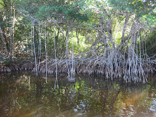
There are really only two seasons in the Everglades: wet and dry. This, the dry season, will end in May. The wet season runs from June to November. Water levels in the 'Glades can vary as much as four feet (Picture 2). The prime tourist season is during the dry season. You can actually walk through many areas of the sawgrass now and wild life is concentrated in those places that still have standing water. Fresh water flows from Lake Okeechobee in the north through a tabletop-flat sea of sawgrass to the estuaries on the southern Florida coast. The water may only move a hundred feet a day--a very slow-flowing river. There it mixes with seawater to form brackish, shallow bays and waterways. One can determine the degree of brackishness by the species of mangrove growing at any point. An inch of elevation difference may make create an environment for a different species of mangrove! Picture 3 shows mangrove roots (both aerial and prop).


Relatively little of the Everglades is accessible by road. If you want to really see the 'Glades, you will need to take a pontoon, an airboat, a canoe, or hike.


Caution would seem to the order of the day if you are moving about the 'Glades. Among the forty-some species of snakes in the Everglades, four are poisonous: diamondback and pygmy rattlesnakes, water moccasins, and coral snakes. Then there are the Burmese python, the Florida panther, alligators, and crocodiles.


In addition the plant life can be deadly. For example, the manchineal tree (picture 3) has beautiful shiny green leaves and apple-like fruit. Two bites of the fruit or rainwater running off the leaves, however, can be fatal.

The Florida Keys


The Florida Keys, the southern- most point in the United States, is a sun- worshipper's and fisherman's heaven! It 123 miles from Homestead, FL, to Key West, the tip of the Keys. (Note: a "key" is an island.) There are no alternate routes--only the one road. We drove our truck but left our camper in Homestead.

Getting to the Keys means driving over miles of causeways, some of them up to seven miles long. The weather was gorgeous--as was the scenery! The pictures pretty much tell the story.

We were advised to drive to the Keys on a weekday, because traffic is impossible on weekends. As it was, we found it difficult to drive our big truck because streets were crowded and narrow. There were many bicyclists, pedi-cabs, and pedestrians in addition to the usual traffic. We had a fabulous seafood lunch near the yacht pictured, walked on the sand beaches and onto several piers.

We saw no commercial ships as we drove to and from Key West, only pleasure boats. Resorts were everywhere. We marveled at the number of RV parks--most jammed full to the point that awnings could hardly be raised.

Tuesday, February 22, 2011

Sugar Cane Harvest in Southern Florida


They really know how to raise "cane" in Florida--sugar cane, that is! It's a major crop in this part of Florida. As we drove from Clewiston to Homestead, we passed cane fields for miles.

There are two processing plants near Clewiston where we camped. Unfortu- nately, we happened to camp downwind from one of them! Anyone who lived near one of the sugar processing plants in North Dakota would have recognized the odor.

Sugar cane is grown in four states: Hawaii, Texas, Louisiana, and Florida. The U. S. produces 27 million tons annually. By comparison, world leader in sugar cane production, Brazil, produces 650 million tons each year. Sugar cane is grown in 110 countries. One planting of sugar cane can produce two to ten harvests with decreasing yields.

Cane is harvested during the dry season. The harvesting machine is shown in Picture 2. It cuts the cane into pieces and drops it in the trailer. Leaves and other light material is left in the field. Cane generally matures in 12 months, but the range is from 6 months to 24 months. Pictures 1 and 2 show a mature field; picture 4 shows a young stand. Where cane is harvested by hand (machete), the field is first burned to get rid of leaves and poisonous snakes. As you can see from the pictures, Florida cane is not harvested by hand.

A fibrous byproduct of cane processing, called bagasse, is burned by the plant to generate power. It is said to be environmentally friendly because it produces essentially only CO2.

The Daytona 500 Race


The Daytona 500, the first race in the NASCAR race season, was a great place to have our first experience with big time stock car races! With a starting field of 43, there was no shortage of action. This year's Daytona set records for most lead changes and most laps under caution. It also produced the youngest winner, Travor Bayne, who celebrated his 20th birthday the day before the race. He was pushed across the line by Bobby LaBonte, a veteran of NASCAR racing.

Daytona has a 2.5 mile track with some steeply banked turns (31 degrees). This is equivalent to a ski slope. It allows speeds of 200 mph through the turn. A new phenomenon emerged during tryouts for this year's Daytona. It's referred to as "hooking up." Successful race drivers have always used "drafting" to gain an advantage. Hooking up goes one step further: instead of just closely following another car, the second car actually pushes the first car. In simple physics, basically what happens is that you have one car with two engines. Hook-ups went on throughout this year's race although the pairings changed as the field was reduced by more than half by the end of the race. In Picture 2 you can see the banked turns and the pairs.

Race attendance, including RVers in the infield and pit crews, was estimated at just under 300,000 people. A unscientific estimate is that several million cans of beer were consumed at the race!

Getting 300,000 people into the stands is a logistical challenge to say the least! Race fans were transported from their assigned parking lots by a fleet of several hundred school buses. An estimated 30,000 cars were parked in our lot. One needs to remember where one parked since everyone in the lot was picked up and dropped off (after dark) at the same point.

Wednesday, February 16, 2011

From the Party Life to the Afterlife...New Orleans


Burial in New Orleans is usually above ground given the high water table. Since New Orleans is an old city, there are a number of very large cemeteries filled with burial vaults. Burial vaults are a status symbol. A large elaborate burial vault is your statement of status if you were wealthy and could afford one. The less well-to-do may rent a vault for five or ten years. These vaults, like the row pictured are nine feet deep. Your remains go into the vault at the front and remain there to the end of your lease. Then your remains are pushed to the back
and another "renter" takes up the front.

You will notice the community vault for the Sisters of Mt. Carmel. There are also extended family vaults.

Note in the third picture, the woman putting flowers in a vase at the front of the St. Leon the Great Mausoleum.

Not every family maintains the rental vaults as can be seen in the fourth picture (a row of vaults with apartment buildings in the background). Typically these less expensive burial options are around the exterior wall of the cemetery.

Tuesday, February 15, 2011

Mardi Gras -- the Business End


Mardi Gras is a billion dollar annual operation for New Orleans. Mardi Gras is a season which begins January 6 and culminates on Fat Tuesday. There are dozens of parades. Clubs called crewes sponsor floats and have their own parades. Large clubs have multiple parades--and as many as 26 floats! Six to ten of these floats are theme floats for the club and do not change. Up to 20 others are decorated annually to fit the Mardi Gras theme for that year. A float can cost the crewe anywhere from $50,000 to as much as $800,000!

Floats are
built on a basic float frame, which is mounted on a heavy-duty four-wheel trailer. All floats are pulled by tractors in the parades. One firm specializing in building the massive floats has 17 ware- houses around the city for refitting and storing the floats. You get an idea of the size of floats from the picture of the two of us standing beside the Trojan Horse.

Most of the characters like the large head in the first picture are created from styrofoam. Many of these characters are used over and over again. They are simply modified by float-building craftsmen to fit the current plan. The day after Mardi Gras work begins on next year's floats. King Kong (see picture) was built for a float but was too tall so is now his own float.