Thursday, March 26, 2009

Scenes from Redding, CA


Redding is in the northern part of California's central valley. This is a very livable area. It's in an area with a wide variety of topography: rich agricultural areas to the south, ranching in the immediate area, forests with winter parks for skiing and other sports, a beautiful lake to the west--a city that's easy to get around in with all the shopping possibilities you could want.

The city also has a world famous pedestrian bridge, the Sundial Bridge designed by renowned architect, Santiago Calatrava of Spain. The bridge, the only bridge in the U.S. designed by Calatrava, is a sundial. However, it does not function as a sundial because of its positioning across the Sacramento River. There is only one day each year when the Sundial Bridge accurately tells time--June 21, Summer Solstice! The bridge deck is constructed of translucent fiberglass panels.

The bridge is part of Turtle Bay Exploration Park and McConnell Arboretum. The Lookout Tree is a living work of art. The artist, Patrick Dougherty, wove vines into the "shelters" pictured around the trees. 

The Mosaic Oasis, a colorful, playful sanctuary, is made from recycled or repurposed products saved from landfills and reinvented into new forms analogous to the butterfly emerging from its chrysalis.

The Arboretum was just beginning to burst into spring bloom when we visited. It covers several acres and includes plant varieties from literally all over the planet. It also provides benches for rest and meditation. 

Wednesday, March 25, 2009

Yosemite National Park


Yosemite National Park is best known for its waterfalls. John Muir, well-known naturalist who explored this area extensively, said: "The clearest way into the universe is through a forest wilderness." In addition to its well-known waterfalls, much of Yosemite is still roadless wilderness. 

We have pictured two of the best known waterfalls in Yosemite, Bridal Veil (first photo) and Yosemite Falls (second photo). These falls are magnificent in themselves but the area surrounding them is some of the most rugged in the Sierras. 

El Capitan is another familiar landmark in Yosemite. It is a huge, bald, granite rock which towers thousands of feet above the valley floor. The last picture gives you an idea of the ruggedness of the Park.

The northern portion of Yosemite is roadless. There are many hiking trails, most of which require skilled, well-prepared hikers. 

In mid-March, when we visited Yosemite, many of the roads and campground facilities were still closed. The drive to the Park entrance and into the campground was over the most challenging mountain roads we've driven on in this trip. Our campground in the Park, Wawona, was on the south fork of the Merced River. After two nights, we left just ahead of a spring storm that deposited new snow at the higher elevations in the Park.

Wednesday, March 18, 2009

Spring in the San Joaquin Valley


Evidence of spring in the San Joaquin Valley is everywhere. The hills are wonderfully green and wildflowers are blooming everywhere.

We are unable to identify the flowers but wanted to share their beauty with you.

In addition to flowers, some orchards are blooming as well. After spending several months in desert, it is good to see green and flowers again!

Sequoia National Park


Sequoia National Park, located in east central California, is known primarily for its giant sequoia trees. It's worth noting that the drive into the Park, known as Generals Highway, is one of the most awesome mountain roads we've ever been on!

Near the Park entrance we came across Tunnel Rock, which you see in the photo. 

The tree in the photos is the General Sherman Tree, the world's largest living tree. It's in an area of the Park called Giant Forest. 

The Sherman is 275 feet tall with the first large branch 130 feet above the base. It's 25.1 feet in diameter 4 1/2 feet above the base; the diameter of the base is 102 feet. The Sherman is believed to be 2300 to 2700 years old. The volume of the trunk is 1487 cubic meters.

Giant sequoias thrive in a narrow elevation range in the Sierra Nevadas where precipitation and annual temperature variation are suitable. 

Mankind has learned a great deal about maintaining these unique trees. For example, they require forest fires or controlled burns to ensure that new trees sprout and continue growing and to prevent forest floor density from causing fires which damage the giants' trunks beyond their ability to heal. Many of the sequoias we saw show evidence of burn damage but they are able to heal most of this damage. 

The three pictures are all of the General Sherman Tree.

Sunday, March 15, 2009

Death Valley - Other Highlights


The twenty-mule team used to transport borax out of Death Valley for more than a century has become a symbol of Death Valley itself. The two massive wagons with their attendant water cart were pulled 165 miles out of Death Valley by twenty-mule teams with each trip lasting 10 days. The total weight of a train was 36 tons including 24 tons of borax. The water was the drinking water supply for the mules and the crew--1200 gallons. For perspective, the rear wheels on the wagons were seven feet tall. 

One of the most famous landmarks in Death Valley is Scotty's Castle. This Spanish-style mansion was not built by Scotty but by a Chicago millionaire couple, Albert and Bessie Johnson. Scotty was a world class storyteller, who once performed with Bill Hickok's Wild West Show.

Scotty's role was to talk the Johnson's into bankrolling his dreams, which it turns out became their dreams. Johnson was an engineer and designed a steam heating system for warmth and a swamp cooler for air conditioning. Fortunately, the property the Castle is located on also contains a naturally flowing spring, which produces 300 gallons a minute of drinkable water. 

The Wildrose kilns are ten beehive-shaped structures, designed to turn pinon wood into coke to be used as fuel in processing silver and lead ore. These kilns only operated for three years and are very well preserved. They are probably the strangest, most improbable industry to be established in Death Valley, where wood is at an absolute premium.


Off-roading in Titus Canyon


In an earlier blog, we said that many of the roads in Death Valley are accessible only by foot or by four-wheel drive vehicle. One such road is the one-way road through Titus Canyon. The road is about 26 miles long and actually begins in Nevada a few miles outside Death Valley. Most of the pictures were shot from the cab of the pickup because getting out was difficult and dangerous.

The initial stretch is a slow, steady climb up an alluvial plain to the base of the mountains. At that point, you begin traveling mountain switchbacks that get progressively steeper and tighter. Well into this stretch we came upon switchback corners that were so short that our 4x4 crew cab Dodge could barely maneuver them. On several outside turns while you are traveling uphill, you made a hairpin turn while looking over the pickup hood into space! The gold-mining ghost town of Leadfield is along this road.

After traveling over the first mountain ridge to the bottom of a valley, we headed into a narrow, rock-walled canyon that wound downward toward the far side of the mountains for several miles. The rock walls rose for hundreds of feet on both sides. 

The last six miles of this road is two-way traffic. Normal vehicles--cars--can travel up this road to the base of the canyon. 

We took other off-road drives such as Artists' Drive, which is actually paved but is extremely steep with some short, tight turns. Twenty Mule Team Canyon and Salt Creek Interpretive Trail are not paved but are travelable by car. Hundreds of miles of other roads in Death Valley are listed as high clearance recommended or four-wheel drive roads only.

One of these roads enters Death Valley at the extreme north end and travels south and west for 50 or 60 miles before it exits Death Valley on the west. This road is listed as being "for experienced four-wheel drivers."

We saw many Jeep-type vehicles that were obviously equipped for this kind of trail--skid plates, double shock absorbers, wide tires, and extra water and gasoline. If off-roading and seeing back country interests you, Death Valley is for you!

Mesquite Flat Sand Dunes


Tawny sand dunes rise nearly 100 feet from Mesquite Flat in Death Valley near Stovepipe Wells. These are called stationary dunes because they are influenced by winds from multiple directions so essentially stay in the same place while changing shapes. 

For photo- graphers, time of day creates dramatic effects. The first two pictures were taken in the evening; the second two pictures of essentially the same dunes were taken in the morning. 

The dunes are a favorite spot for hikers and photographers. If you look closely, you will see hikers in pictures two and three.

In the background you can see the typical barren mountains of the Valley; in the foreground of several pictures, you will see desert with its sparse foliage.

Flora and Fauna of Death Valley


Given its dryness and extreme heat only the hardiest of plants and animals flourish in Death Valley. The two animals we pictures are almost legendary for their survival skills. Apparently, wild burros are not seen often in the Park. Their primary range is southwest of Death Valley. Coyotes, of course, are everywhere. One of the big problems in Death Valley is that tourists want to feed them, which actually threatens their survival.

There are big horn sheep in the Park, but we did not see any. The most talked about animals in the Park is the sidewinder. We did not see one in spite of miles of hiking. We did catch sight of a kangaroo rat, but couldn't get a picture.

One of the other truly unique species in Death Valley are the pupfish. There are actually about ten species of pupfish--all of them on the endangered list. These fish survive in very saline water, are tiny, and are being studied in their native environment in the Park.

It would not surprise you that in an environment this extreme, there is no vegetation or very sparse vegetation over vast areas. The plants that do exist have adapted to the extremes of heat and drouth. 

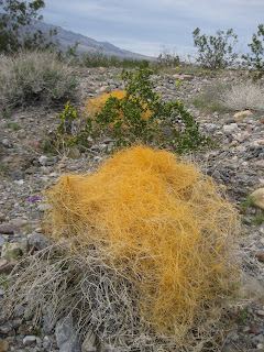
The orange-colored, stringy-looking plant you see in the photo is Dodder. It is a parasitic plant. It lives entirely off other plants and has no roots into the ground at all. It frequently kills its host plant. You can see the host plant beneath the Dodder in the photo.

The fragile flower is called the Gravel Ghost. It is amazingly beautiful and fragile considering the environment in which it lives. 

Many of these plants bloom only for a brief period in the early spring if there is adequate rain. 

Death Valley - The Big Picture


Death Valley National Park was created by Congress in 1994. Previously, Death Valley had been designated Death Valley National Monument since 1933. The Park has grown in size from 1.6 million acres to 3.4 million acres. It is one of the largest protected desert environments in America. The Park is over 150 miles from north to south and more than 50 miles across at the middle. Huge segments of the Park are inaccessible or accessible only by foot or high clearance four-wheel drive vehicle.

The Park is one of the driest places on the planet, averaging two inches of rainfall annually. Because so much of the Park is mountainous, any rain can result in widespread flash flooding. Vast areas of the Park are made up of alluvial fans washed down out of the mountains by these floods. Death Valley is the hottest, driest, lowest national park in the U.S. Summer daytime temperatures often reach 120 degrees and may not drop below 100 degrees at night. 

Badwater Basin is 282 feet below sea level. (Note the Sea Level sign high above Badwater Basin). The snow-capped mountain which you see in the background rises to 12,000 feet above sea level. The Park is in an active earthquake zone and over the eons has been heavily affected by volcanic activity.  The most recent volcano, which formed the Ubehebe Crater near the northern end of the Park, erupted about 2000 years ago.

In spite of the extremes, Death Valley has attracted some interesting people and within the Park there is a diversity of interesting places, which we will feature in additional blogs.

Monday, March 9, 2009

Palm Springs Aerial Tramway


The Palm Springs Aerial Tramway features two 80-passenger enclosed cars which rotate 360 degrees as they ascend to the top of the mountain. The tram rises through rugged Chino Canyon from 2600 feet to 8600 feet in just over twelve minutes. At the top of the mountain is San Jacinto State Park & Wilderness, a California state park. The temperature was 70 degrees at the bottom and 40 degrees at the top on the day we visited. 

The view from the top is truly spectacular. A number of California cities, including Palm Springs and Desert Hot Springs, are visible in the valley below. At the summit there are hiking trails ranging from 1 mile to 54 miles, and many winter sport activities.

There is a restaurant and several gift shops at the summit. Of course, all supplies, including drinking water, must be delivered to these facilities. Fresh water is carried up the mountain on each trip of a tram car, 800 gallons at a time. Groceries and other goods are carried up during the night. Employees ride the cars to work as well.

Helicopters were used to construct four of the five supporting towers. The Tramway has been designated an historical civil engineering landmark.

Los Angeles County Museums


Sunday, March 8, we visited the LaBrea Tar Pits and the Los Angeles County Museums with friend Margaret. We joined a tour at LaBrea, where the guide explained that, in spite of the posed mammoth "stuck" in the tar, it was a rare event which seldom occurred over hundreds of thousands of years. The Museum is currently excavating a mammoth which is nearly intact. It was discovered while preparing to build a parking lot for the museum. The mammoth may be the most complete skeleton discovered. It will take a number of years to complete its removal from the tar pit.

We also visited the LA Art Museum, which included an outdoor display of street lights. Inside the museum, one of the major exhibits was of German World War II artworks. The German works were disturbing works depicting a troubled time. We were unable to take pictures inside the museum.


Irish Fair in Pomona, CA


March 7 we joined dear friends and family at the annual Irish Fair at Pomona Fairgrounds near Los Angeles. 

The Fair, which has gone on for several years, features Irish music and dancing, food, and merchan- dise.  We were unable to get good still shots of most of the musical groups or dancers, but if you're ever in the area around St. Patrick's day, plan to spend time at the Fair! While a variety of Irish music groups performed, we especially enjoyed a group called Slugger O'Toole, whose CD we bought to enjoy on our travels.

It was great to share the experience with our friends, Marianne, Mike, Marge, and Norman--all educators! Marianne is Anita's cousin; Marge is a college friend. The women are all part Irish; the men are Irish by choice...

We had dinner with Marge and Norman at a beach restaurant near Marge and Norm's home in Los Angeles. Note the ferris wheel in the nearby amusement park.


Friday, March 6, 2009

Keys' Gold Mine in Joshua Tree National Park


Bill Keys operated a two-stamp process gold ore processing mill named the Wall Street Stamp Mill in what is now Joshua Tree National Park. The mill is about a two-mile walk (one way) from the parking area.

Keys processed his own ore as well as that brought to him by other miners.  The mine is on the national historical registry. 

The first picture shows what remains of the mill. The second picture is a look at some of the machinery inside the mill.

The National Park Service's explanation of a two-stamp gold milling process is a bit hard to read but provides a good overview of the refining process from raw ore to processed gold which was sent to the Mint or smelter.