Friday, June 26, 2009

Sentinel Butte


Sentinel Butte, ND, Tom's home town, was the last stop on our nearly ten-month-long RV odyssey. Sentinel Butte is 17 miles west of Medora and 2 miles south of Interstate 94 in western North Dakota. In many ways, Sentinel Butte is not unlike many other small commu- nities in North Dakota with populations of 200 or fewer. 

It is different in a couple of ways that really count. Some of you may remember stories that made national news a few years back about a small community where everybody in town had a key to the gas pump. Fueling up was completely on the honor system. 

Buzz Olson was the owner of the station when that story broke. The station still operates on the same honor system. These days the station is run by Rick Olson, son of Buzz and current mayor of Sentinel Butte. It may be useful to note here that this service station is the only business operating in the community. The station these days provides fuel but is also the gathering place for members of the community. Morning coffee is a daily ritual.

Fridays, however, are special. Each Friday noon the community assembles for a potluck with Mayor Rick Olson grilling steaks, burgers, and hot dogs. Other community members or visitors--like us--are welcome to participate in the Friday potluck. You can bring a dish to share or put your contribution in the jar and dig in.

Mayor Rick never knows who or how many will show up. It could be anywhere from a dozen to 35 people. In typical western fashion, you'll note that men and women sit in separate areas as shown in the picture. Even though this hasn't been Tom's home town for many years, it is a very comfortable place to visit and the Western hospitality can't be beat! 

It seems that the USA could benefit from other communities following Sentinel Butte's example.

Wednesday, June 24, 2009

Hang Gliding in Wyoming's Big Horn Mountains


Some of the most memorable moments on our trip are totally unplanned! Watching a hang glider step off the side of a cliff part way up the Big Horn Mountains south of Dayton, Wyoming, was one of those events. 

We were driving up the pass and pulled over at a lookout point to take in the view of the valley below. As we pulled into the parking lot, a hang glider was preparing to launch. We joined a number of other spectators to see him fly. In the few minutes we had before launch, we found out that the flyer was from Colorado, had about 35 years of experience and a thousand hang glide flights. His companion had "flown" about 30 minutes earlier.

To the casual observer, the process and equipment are deceptively simple. We watched as he calculated the wind, stepped off the cliff, and was airborne. He glided toward Dayton, catching updrafts frequently, and eventually landed about half a mile south of the city within a couple hundred yards of the highway we'd driven to the pass. He said before he launched that within 30 seconds of stepping off the cliff he would be 1700 feet above the ground over the foothills of the Big Horn Mountains. We estimate that he traveled five or six miles as the crow flies. His route was anything but straight, however.

The pictures sort of tell the story...

Little BigHorn Battlefield - Indians


Throughout most of our history since the Battle of the Little Big Horn in 1876, little recognition was given to the "other side" in this battle, the native Americans who fought bravely in defense of their way of life. In December 1991 the official name of the battlefield was changed from Custer Battlefield National Monument to Little Bighorn Battlefield National Monument. 

The Indian Memorial near Last Stand Hill was dedicated June 25, 2003, as part of a movement to bring a more balanced perspective to the Battle of the Little Bighorn. "Peace Through Unity" became the battlefield theme.

Reports from survivors on both sides of the battle indicate that their opponents fought bravely and well. The placement of Warrior Markers, made from red granite, was initiated in 1999, to mark locations where Indian warriors fell. Identifying warrior death sites is more difficult because their bodies were removed following the battle. Park Service experts are working with the various tribes to determine the number and death location of native American casualties. While the exact number of Indian losses is unknown, historians estimate that there were 60 to 100 killed. 

The native American encampment on the Little Bighorn River prior to the battle was estimated to include up to 7000 men, women, and children; and scouts estimated that the encampment may have included a herd of horses running into the thousands. Scouts from the Seventh Cavalry spotted the encampment from a lookout point approximately 14 miles to the east as they approached. The first concrete evidence of a large encampment was the very large herd of horses. Custer's intention was to surround this large encampment before they could disperse.

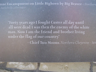
A national contest was held to design an Indian Memorial on the battlefield site. The first picture is from a granite marker in the Memorial. The message of Chief Two Moons, one of the Northern Cheyenne leaders in the battle, reflects the new spirit of the battlefield: "Forty years ago I fought Custer all day until all were dead. I was then the enemy of the white man. Now I am the friend and brother living under the flag of our country."

The second photo shows the Spirit Warriors Sculpture on the Memorial. The final picture shows a section of the circular memorial with marble panels commemorating each of the native American tribes involved in the battle.

Little Bighorn Battlefield - Cavalry


Just before the celebration of the nation's 100th birthday in July 1876, one of the last armed efforts of the Northern Plains Indians to preserve their ancestral way of life took place in Montana at the Battle of the Little Bighorn. 
The battle between the U. S. Cavalry, under the command of Lt. Col. George Armstrong Custer, and combined forces of Lakota, Cheyenne, and other tribes of the Great Plains estimated at 1500 to 2000 warriors took place on June 25 and 26, 1876. It should be noted that Custer divided his 600-man force into three battalions--one led by Custer, one led by Marcus Reno, and the third led by Frederick Benteen. Historians believe that Custer underestimated the size and fighting capability of the Lakota and Cheyenne forces. 

We visited the Battlefield just a couple of days before the anniversary.

The battle was but one encounter in a conflict that began with the arrival of Europeans in North America. Discovery of gold in the Black Hills, the refusal of the Indians to sell the Black Hills, and the influx of gold-seekers to an area considered sacred by Native Americans hastened this violent clash of cultures. The policy of the U. S. Government under U. S. Grant was to move native Americans to reservations.

The battle took place over an area about 5 miles long on ridges and in ravines north of the Big Horn River near what is now Hardin, Montana. Visiting the battlefield, hearing the Rangers talk about the incidents that led up to the battle, and walking the site brings this poignant piece of history into sharp perspective. Scattered throughout the battlefield are markers showing where soldiers, scouts, and civilians of Custer's unit died. This is one of two battlefields in the world where specific combatants fell. 

The first picture is a diarama in the Visitors' Center Museum, depicting the battle. The second picture was taken from Last Stand Hill, where Custer and the last of his unit died. The Seventh Cavalry Memorial, in the third picture, stands at the top of Last Stand Hill. The Memorial inscription reads, "The remains of about 220 soldiers, scouts, and civilians, are buried around the base of this Memorial. The white marble headstones [picture 2] scattered over the battlefield denote where the slain troopers were found and originally buried. In 1881 they were reinterred in a single grave on this site. The officer's remains were removed in 1877 to various cemeteries throughout the country. General Custer was buried at West Point." The final photo shows where Custer fell.

Over 260 soldiers and attached personnel died during the battle. Custer's entire immediate command was killed. The lone survivor was a horse called Comanche.

This normally semi-arid part of Montana was beautifully green during our visit. The view from the battlefield area is awesome. Visiting this battlefield gives one greater perspective on the stories and myths about the Custer Expedition.

Thursday, June 18, 2009

Buck Knife Headquarters in Idaho


A short distance from Spokane, in Post Falls, Idaho, we stopped to tour the Buck Knife manufac- turing plant. We became aware of the plant through a young cousin of Tom's, Toni Decker, who works at Buck. She encouraged us to tour the plant.

Tom has had a Buck hunting knife for years. He is convinced they are, without a doubt, among the finest knives in the world. Buck produces a standard line of knives but also produces specialty knives at customer request. If you own a Buck knife, you can send it to the 
plant and they will sharpen it for $5. 

Buck knives were first produced in 1902. The Buck family has continued to manu- facture a variety of knives in their facilities. The plant, originally established in California, was moved to Idaho in 2004. 

In the first picture Tom is standing beside a water feature which is in front of the building. The second picture shows the huge entry hall, complete with an antler chandelier. There are a number of mounted trophies throughout the foyer. 

The third photo shows mastadon tusks, two of many found in a quarry in Alaska. Some Buck knives have ivory handles made from these tusks. The final photo is of a water buffalo.

We toured their production facilities and were impressed with their attention to quality and detail. Although no photos were allowed on the tour, it struck us as a well-organized, state-of-the-art factory. We were also impressed by the number of women who held responsible positions on the manufacturing floor.

Monday, June 15, 2009

Grand Coulee Dam


Grand Coulee Dam is the largest concrete structure on the planet and the largest hydro- electric project in the U.S.  Its turbines are capable of producing 6809 megawatts. It generates more power than a million loco- motives. And that's just the beginning of impressive statistics about the size and capability of this dam. 

It took nine years, starting in 1933 during the Great Depression, to build the dam. Thousands worked around the clock, finishing the dam in 1942. Its 12 million cubic yards of concrete could build two standard six-foot wide sidewalks around the equator. The latest addition, completed in 1980, is the third power house (on the left side of the dam in the first picture). 

The second picture is a view of the third power house from the top of the dam. Its six turbines generate 80 percent of the power at the dam. Three turbines of the six in the new powerhouse are the world's largest turbines. The turbine shafts are 11 feet in diameter; the bolts used to bolt sections of these shafts together weight 900 pounds each. The new powerhouse functions primarily as a peak demand generator. 

The six feed pipes that bring water to the turbines in the new powerhouse are 40 feet in diameter. Two of those pipes at full capacity equal the flow of the Colorado River, according to our tour guide.

The dam actually has three important functions: irrigation, power production, and flood control. Electricity was not foreseen as its primary function when the dam was built, but today is one of the Dam's most important jobs. The pipes you see on the left hand side of the third picture are irrigation water pumps that life water from the Lake Roosevelt up 280 feet to allow water to flow into Banks Lake for irrigation and municipal water. Water from Grand Coulee Dam irrigates more than 500,000 acres today.

The final picture shows an osprey nest on top of a power pole near the dam. Ospreys are impressive birds of prey. In addition to very effective fish-catching skills in the dam, the ospreys have also virtually eliminated the pigeon problem around the dam. Managers at the dam audiotaped an osprey and play the tape periodically near the top of the maintenance crane on the dam. The crane is no longer "fowled" by pigeons.


Sunday, June 14, 2009

The Great Alaskan Lumberjack Show


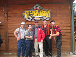
The Lumberjack Show in Ketchikan is a perfect combination of serious chain saw/logger competition and theatrics to make it great fun. Many of you may have seen lumberjack competi- tions on TV. All four of the guys in this show compete in these competi- tions. The equipment they use for the show is the same equipment they use in competi- tion. They are all outstanding athletes. 

A couple of them have great senses of humor as well. The show featured the usual logger competi- tions. We couldn't picture all of them but couldn't resist taking a picture of Tom with them.

The third picture features horizontal chopping on a short length of log. The lumberjack stands on the log and chops through in seconds with razor sharp axes...very close to his own feet. There was a similar vertical chopping competition. We also saw pole climbing, a race up and down a 50-foot pole; two-man cross-cut sawing; "hot" saw competitions; and log rolling.

The final picture features axe throwing in which you get three throws with a double-bitted axe. Whoever accumulates the most points (based on the rings in the target log) is declared the winner. In this picture, you can see the double-bitted axe in flight (toward the left edge of the brown building).

The Red Dog Saloon


Juneau's famous Red Dog Saloon caught Tom's eye! Those of you that are big fans of the late Johnny Horton (as Tom is) will recall his song, Springtime in Alaska. If you haven't listened to it lately, you might want to find it and listen to it again. One line in the song talks about "taking a stroll to the Red Dog Saloon." 

This is THE Red Dog. Pictures of the interior were difficult to get because the place was full. The bouncer let Tom in to take pictures, but we couldn't stay because it was over legal capacity. (Remember: this was a day when an estimated 9000 cruise passengers were visiting the city, whose permanent population is around 35,000.) As you can see from the pictures, every square inch of the interior is covered with frontier paraphernalia. 

Juneau, Capitol of Alaska


Alaska's capitol, Juneau, is the second of the three cities we visited on our cruise and is the most picturesque city we visited in Alaska. The first photo is taken from the Mt. Roberts' tram, high above the city. As you can see, the city sits on a narrow slice of land between the mountains and the bay and stretches along both sides of the bay for quite a distance. You can see several cruise ships in port in the lower left hand corner of the picture. There were four cruise ships in port that day; our ship was just to the left of those pictured.

We walked through the city, past the state legislative building and on to the governor's mansion. Juneau is sometimes compared to San Francisco because of its hills. The walk from the ship to the governor's mansion was uphill most of the way.

The last two pictures are of the governor's mansion, the 12th oldest continuously occupied executive residence in the country. Governor Sarah Palin has chosen not to reside there all the time. Alaska's legislature meets only 90 days every other year. 

Of special note, Alaska celebrates its 50th anniversary as a state this year. Juneau is the only state capitol that shares a boundary with a foreign country, Canada.  The city is accessible only by sea or air. A long-running debate about building a road to Juneau continues!

Throughout Alaska there are many totem poles, such as the one in the third picture beside the mansion.

Tuesday, June 9, 2009

Skagway, Alaska


Skagway's place in history was established by the 1897 Klondike Gold Rush. It came into existence as one of the jumping off points to the gold fields on the Yukon River near Dawson City, Yukon Territory, Canada.

It's estimated that as many as 100,000 people left at least 38 different countries on the planet to strike it rich in the Klondike. At its peak, Dawson City, the center of gold fever, had a population of 40,000. Main Street included eighty saloons, along with a wide assortment of related frontier community establish- ments. Mining companies and resident prospectors had claimed all of the ore-rich sites long before most of the gold-seekers ever reached Dawson City. The vast majority never mined an ounce of gold. However, over the last 100 years, 12.5 million ounces of gold have been mined from this area. First reports of the Klondike gold strike were brought to the lower 48 by passengers on two ships months after the strike was actually made. One of them carried two tons of Alaska gold which created sensational headlines and helped to generate one of the most irrational gold fever incidents in history.

Skagway is now a town of just over 800 people. It is five blocks wide and 20 blocks long, confined by mountains and the bay. It is devoted almost exclusively to tourism. The day we were in Skagway there were four cruise ships the size of the Sapphire Princess anchored in Skagway Harbor. They could easily have brought 6000 people to town. On our walk up five blocks of the main commercial district, we counted 28 jewelry stores. And there were that many more that probably sold jewelry as well as other products.

The old Cadillac and the horse and buggy are just a few of the ways that Skagway caters to tourists. The red snowblower was used to clear rail tracks during winter in an earlier era. It was steam-powered. The building, now the Skagway City Tourist Information Center, is sided with driftwood, none of which exceeds three inches in diameter. 

Glacier Bay National Park


Our most spectacular glacier-viewing was in Glacier Bay National Park. Our ship spent time near Margorie Glacier and Grand Pacific Glacier. Margorie Glacier is at the end of Glacier Bay. The cruise up the bay included awesome scenery and a whale sighting.

National Park rangers joined us onboard the Sapphire Princess and provided information, education, and commentary over the course of the cruise into the Bay. Margorie Glacier is exactly what first-time glacier watchers would expect to see. It's massive! Parts 
of it extend 25 miles up into the mountain valley. (See Picture 4.) When our ship was within a quarter of a mile, the glacier towered over the ship. Magorie is an old glacier--blue color indicates tremendous compression the result of up to 300 years of snowfall. 

When you get anywhere close to a glacier, you begin to hear the sounds of shifting and cracking. If you're lucky, you'll hear the sound of a glacier "calving," as chunks of ice from the leading edge break off and fall into the bay. (See picture 3.)

For historical purposes, during the Little Ice Age (in the 1700s), there was only one glacier in Glacier Bay. It covered the entire bay and extended into the ocean and was reportedly 4000 feet thick at the leading edge. If you look at a map of Alaska, you can get a perspective on the change. Margorie today is miles away from what would have been the leading edge of the glacier in the 1700s.

College Fjord


The first leg of our trip by cruise ship was glacier viewing at College Fjord in Prince William Sound. 

The fjord contains five tidewater glaciers (glaciers that terminate in water), five large valley glaciers, and dozens of smaller glaciers, most named after renowned East Coast colleges (women's colleges for the northwest side and men's colleges for the southeast side). College Fjord was discovered in 1899 during the Harriman Expedition, at which time the glaciers were named. The expedition included a Harvard and an Amherst professor, and they reportedly "took great delight in ignoring Princeton."

In 1964 College Fjord was the epicenter of the Good Friday Earthquake, the most powerful earthquake in U. S. history. From one place, it is possible to see eight of the College Fjord's glaciers at once.

The scenery in the Fjord is awesome, made special the day of our visit, by the clear weather, something unusual in this part of Alaska. It is worth pointing out that all of Alaska's glaciers have shrunk dramatically in recent years. 

The Sapphire Princess


As first time cruisers, our first reaction is "now this is a SHIP!" We've done a lot of wilderness walking, but it's really fun to walk here: the ship is 290 meters long (3 football fields)  and 50 meters wide. Three laps around the ship's rail on the seventh level equals a mile. And you don't stumble over roots or rocks! 

The Sapphire Princess is one of the ships of the Princess line. It is designed to entertain adults 24 hours a day,
although children also cruise. Our cruise has 186 children and teens. It has five pools, a couple of theaters, and five or six lounges. Service and food are excellent!  Other ship data: it weighs 115,875 gross tonnage, 77,745 net tonnage, carries 3500 tons of fresh water, carries 2670 passengers and a crew of 1120. While we've not been on anything that would qualify as rough seas, the ride is incredibly smooth. 

As you can see in the second photo, the bridge is wide. The captain can operate from either side. Our favorite viewing spot is from the deck above the bridge. Our stateroom and deck are midship on the 11th floor, starboard. The elevator goes to 16 and there is a disco on the 18th floor, aft. 

The last picture is from the stern as we left College Fjord, after a day of glacier viewing. You can't really tell from the wake, but the ship is driven by four propellers.

Friday, June 5, 2009

The Iditarod


The Iditarod, known as the Last Great Race on Earth, covers over 1150 miles from Anchorage to Nome. Each musher has a team of 12 to 16 dogs.

Joe Redington, Sr., is known as the father of the Iditarod. Redington, a native of Oklahoma, moved to Alaska in 1948 after serving in World War II. In Alaska, the Oklahoma homesteader was a big game guide, bush pilot, commercial fisherman, boat builder, fish plant manager, and mountain climber. His big love, however, was dogs and dog mushing. In 1979, at 
age 62, he mushed a dog team to the summit of Mount McKinley. Thanks to his tenacity, the Iditarod evolved into the event it is today.

The Iditarod has evolved into a highly competitive sport. In 1973, the winning time was 20 days, 49 minutes, and 41 seconds. In 2009, Lance Mackey covered the same distance in 9 days, 21 hours, 38 minutes, and 40 seconds! Mackey, who is a cancer survivor, won the race in 2007, 2008, and 2009.

Several women have won the race as well--some more than once. The most famous one is Susan Butcher. 

Tom got the feel of dog sledding by riding behind eight dogs at the Alaska Iditarod headquarters. The dogs pulled a rubber-tired cart around a short track while the musher steered from the back of the cart.

Anita fell in love with some future sled dogs, two of a litter of five pups. Dogs used in the Iditarod are selectively and specifically bred for the race. They represent a winning mushers' kennel. Obviously, winning the Iditarod does great things for the value of your kennel's pups.